The Vikings & Geothermal Iceland
Why and when did the Vikings come to Iceland—the land of fumaroles, geysers, thermal waters, and volcanic eruptions? And what happened next? It’s quite a story.
Did the Vikings ever imagine so much heat lay beneath the snow and ice around them—although the climate was a bit warmer back then? Probably not, but why should they? Most of them hailed from Norway, a country with geological stability; a land of ancient metamorphic and sedimentary rocks; and one with no signs of heat but for a tiny spot in the far north and another on the ocean floor. Sure, earthquakes rumbled through occasionally and a few warm springs bubbled in that Arctic archipelago, but the pools of water in the quiet Norwegian woods were cold, and the forested mountains didn’t spew vast clouds of steam, ash, and rock high into the sky; turn snow and glaciers into roaring rivers; or extrude flowing, fiery ropes and sheets of immolating lava. The Norwegian mountains were tree-covered and still; they weren’t volcanoes.
Beginning around 863 A.D., or a bit earlier, Viking ships, many from Norway, began making short Icelandic stopovers. The trip from Norway took about four days in good weather.
In about 871 A.D., a large volcanic eruption dusted most of Iceland in a thin layer of volcanic debris, today called the Landnám tephra. (Tephra is a mixture of fragmented, volcanic products, like ash and cinder.) The tephra layer helps to date Icelandic settlements around the island, for no indications of Viking life have ever been found beneath this layer—except for one grain of barley pollen near the capital city, Reyjavík.(2)
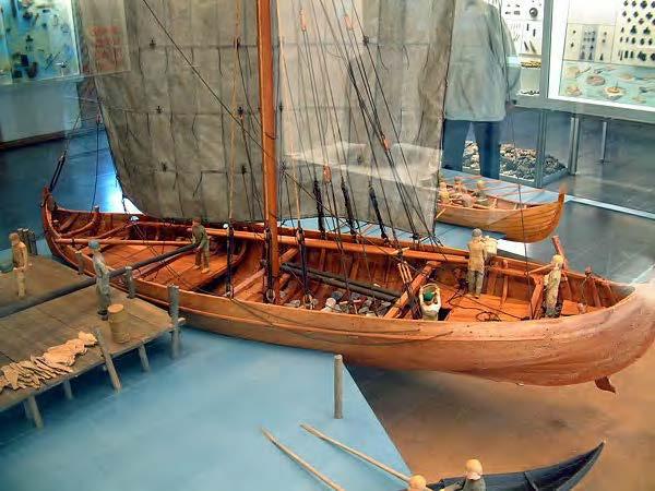
The Icelandic Age of Settlement dates from 874 to 930 A.D., a time of great change. In 874 the first group of Viking farmers moved permanently to Iceland. They came from Norway, and their leader, Ingólfur Arnarson and his wife Hallveig Fróðadóttir, brought along family members, farmhands, and seasick sheep and cattle. On reaching the shore, they climbed freezing from the cargo ship, called a knarr, to begin their new lives.
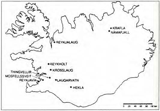
As they stepped on Icelandic soil, they were standing not only on an island with nine active volcanoes, but one with five of the volcanoes close by, arrayed along the southern coastline. From 874 to 930, the Vikings would build many settlements among the five volcanoes—including Ingólfur and his family, who settled down in a place he called Reykjavík.
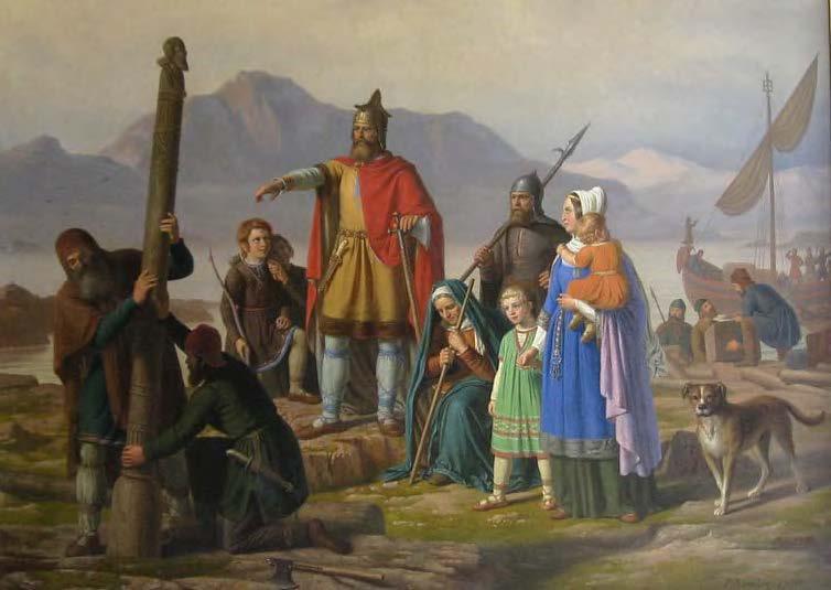
Ingólfur chose Reykjavík for his home in an unusual way. Before landing in Iceland, but with land firmly in sight, he tossed his pair of carved, sacred, high-seat pillars overboard—vowing to settle wherever they washed ashore. According to legend, after three years of searching he found the pillars at the edge of a bay he named Reykjavík (“smoky bay”, from the Old Norse) for the active hot springs and fumaroles around it.(4) Eventually many other Icelandic sites were given geothermal names, as well.
It turns out the Vikings weren’t the first to settle in Iceland. Christianity arrived before them, brought to the island by hermitic Irish monks who lived in caves—possibly inside the lava tubes. Commenting on the long Icelandic days and short midsummer nights, a monk once wrote, “... whatever task a man wishes to perform, even to picking the lice from his shirt, he can manage as precisely as in broad daylight.”(4) When the Vikings arrived, the monks fled in a hurry, leaving behind many personal effects in the rush to get away.

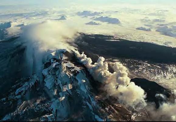
Mount Hekla, one of the five southernmost coastline volcanoes—and still very active, has erupted well over 20 times since 874 A.D. During the fiery eruption of 1104, huge blankets of tephra destroyed at least 20 farms in southern Iceland. One such farm, named Stöng, has been excavated, rebuilt, and opened to the public. The farmstead is preserved perfectly, like an Icelandic Pompeii. The sod walls were left nearly intact beneath the thick layers of tephra.(4)
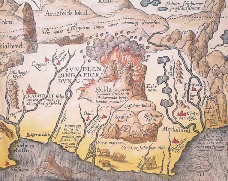
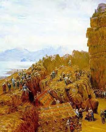
Inspired by the 1104 eruption, monks began spreading tales throughout Europe that Mount Hekla was a gateway to Hell. This speculation is illustrated dramatically in books and maps from The Middle Ages—as you can see on the 1585 map of Iceland reprinted above. Notice how Mount Hekla, the largest feature on the map and one covered in flame, spews dark smoke and volcanic bombs—the arc of black dots above the smoke.
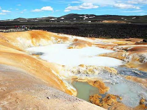
Dr. Sindrason worked for the Nordic Volcanological Institute from 1975 to 1984. During that time, he and others studied Krafla, a volcano mentioned in the hot springs photo caption.
When I asked Dr. Sindrason about his Viking ancestry, he said it was “a bit too long ago.” He thought I had meant family stories from the last several hundred years, but I’d really wanted him to go back 1,000 years or more. Impossible because he was right; the events were “a bit too long ago.”
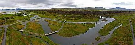
Back in 930, 201 years before the 1104 eruption of Mount Hekla, the first Icelandic national assembly, called the Althing, met at Thingvellir (“Parliament Plains”) about 50 km from Reykjavík. Today Thingvellir is a National Park and an UNESCO World Heritage Site. Its long and incredible expanses of lava form part of the mid-Atlantic ridge.
The Vikings created the Althing to establish a common code of law suitable for a republic (not a monarchy) and to settle disputes. Here was where the Law-Speaker spoke to the assembled Vikings in front of the great wall of lava. “The riven wall of lava made a splendid sounding-board for speakers’ voices in those days before microphones and amplifiers were invented.”(4)
By the year 1000, just 70 years later, the King of Norway was pressuring Iceland to renounce paganism and accept Christianity. Icelandic political opinion on the matter was polarized into two bitterly opposed factions. War seemed imminent. Sensing a crossroad, the leader of the Christian party, Hall of Siða, asked the Law- Speaker of the Althing, a pagan named Thorgeir Thorkelsson, to arbitrate. Everyone swore to follow his decision.
After considering the situation for a day and night, and in the interests of peace, Law-Speaker Thorkelsson declared that all unbaptized people in Iceland should become Christians and be baptized—meaning they would be submerged in cold water. Now real trouble arose. The Icelanders agreed to become Christians only if hot water was used in the ceremony.
And so it was. People from northern and southern Iceland were baptized in a hot spring named Reykjalaug (later called Vígðalaug, “the consecrated spring”) at Laugarvatn. Those from western Iceland were baptized in a hot spring named Lundarreykjadalur (later called Krosslaug, “the spring of the cross”) at Reykjalaug. Since then, both of these hot springs are said to hold healing powers.(3)
Iceland lost its independence to the King of Norway in 1262 and together with Norway to the Queen of Denmark in 1388. Toward the end of the thirteenth century, the Norwegian Archbishop of what today is Trondheim apparently won exclusive rights to buy and transport native sulfur from Iceland. The sulfur was collected from locations known today to include high-temperature geothermal fields. Exactly what the sulfur was used for is unclear, as gun powder hadn’t yet been invented.(3) Some say the Catholic Church may have exported the sulfur to European churches so the congregations could grow familiar with the odor of hell.1 Icelandic sulfur rights—sometimes quite valuable—were controlled by the Danish King for many years until the rights were returned to Iceland in the 1760s.(3)

How many hot springs are in Iceland? The count includes 250 thermal areas and 600 major hot springs. Surprisingly, geothermal expert Ingvar Fridleifsson finds no correlation between natural hot spring locations and the sites where early Vikings chose to build the farmhouses. Even the first settler, Ingólfur Arnarson, built his own farmhouses about 3.5 km away from the nearest hot spring, apparently preferring a good landing beach for his boats to the luxury of nearby hot waters for things like bathing, laundry, and cooking—not his duties, after all.(3) Several years ago, parts of his farmhouse were discovered under the southern end of Reykjavík’s Aðalstraeti (“Main Street”) that runs down to the harbor.(4)
In the eighteenth century, hot springs were considered “nuisances” by some farmers who were quoted in a book titled, Description of the Farmsteads of Iceland, 1703-1714. One farmer said, “A part of the hay field is spoiled by a hot secretion caused by a nearby hot spring.” Another complained, “Storms are fierce so that both houses and haystacks are in danger. The water is warm (read ‘undrinkable’).”(3)
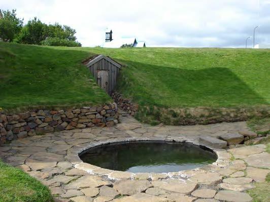
Only one pre-twentieth century archaeological structure exists where hot spring waters may have been used for space-heating. This is in the farmhouse (barely seen in the photo) built behind a hot water pool called, Snorralaug (“Snorri’s bath”), in the village of Reykholt. Snorralaug itself is the only ancient (probably 13th century), man-made bathing structure still standing in Iceland, and it resembles a 4 meter wide, stone-sided, backyard hot tub.
Built by powerful chieftain, famed historian, and writer of sagas, Snorri Sturluson (1178-1241), Snorralaug was heated with steam and hot waters flowing through two conduits from a nearby hot spring, called Skrifla. A third conduit from the hot spring bypassed Snorralaug entirely and went straight to the farmhouse in back. Were at least some farmhouse rooms warmed by geothermal heat? Perhaps, yes.
We do know that for over a millennium, thousands of Icelanders living in a very cold climate never used the nearby hot waters to warm their houses. In 1908, perhaps the first person to do so was a farmer at Reykir in Mosfellssveit, Stefán B. Jónsson (1861-1928). He brought hot spring waters through a 2.3 km pipeline into his home to heat the radiators. Not long after, in 1911, Erlendur Gunnarsson, from Sturlureykir in Western Iceland near Reykholt, invented a simple mechanism to separate the steam from the hot water in a boiling spring next to his house. He used the steam for cooking and heating.(3) The two installations, invented over a century ago, began the modern era of geothermal development in Iceland.
Selected References
- Björnsson, L., 1994, Personal communication, from Fridleifsson, Ingvar Birgir, 1999, Historical Aspects of Geothermal Utilization in Iceland, in “Stories from a Heated Earth,” Cataldi, Raffaele, Hodgson, Susan F., and Lund, John W., eds., published by the Geothermal Resources Council and the International Geothermal Association, Davis, California.
- Fitzhugh, William W. and Ward, Elizabeth I., 2000, Vikings, the North Atlantic Saga, published by the Smithsonian Institution Press, in association with the National Museum of Natural History, Washington, D.C.
- Fridleifsson, Ingvar Birgir, 1999, Historical Aspects of Geothermal Utilization in Iceland, in “Stories from a Heated Earth,” Cataldi, Raffaele, Hodgson, Susan F., and Lund John W., eds., supra.
- Magnusson, Magnus, 1980, VIKINGS!, published by E.P. Dutton, New York.
Acknowledgments
Thanks to Brian Billings for helping with the Latin translation, and to Dr. Sigurjón Sindrason for kindly answering my questions.