Plaine de Garonne Energies (PGE): A New Geothermal District Heating in Bordeaux, France
Plaine de Garonne Energies is a joint venture between Storengy and Engie Cofely in charge of the construction of a large district heating network, mainly supplied by renewable energies, in Bordeaux (France). Geothermal is a major solution planned to provide the new Plaine de Garonne district with heat, on the right bank of the Garonne river.
In 2015, the Bordeaux Metropole called for a geothermal project, for supplying heat to several districts, with the additional ambition to explore deeper formations for even hotter resource, namely the Jurassic expected at a depth of ~1,700m.
Storengy proposed its expertise in geosciences and its experience in both exploration and drilling, as well as geothermal project development in Partnership with Engie Cofely.
Through the subsurface studies, Storengy geologists, reservoir engineers and well engineers were able to propose an innovative design of a doublet (of wells), in allowing for both exploring and yet to be characterized deep Jurassic layers, and ensure a fallback to the proven upper lying Cretaceous aquifer. This project is a challenge both technically and in terms of management because of exploration risks, budget constraints, and the upper stringent objective of delivering heat to the district network. To comply with all these objectives, vertical wells were designed with an innovative technical solution with no sidetracking.
This project illustrates that Storengy and Engie companies are fully committed in finding innovative and efficient solutions for deep and shallow geothermal energy supply energy to cities and communities.
By choosing geothermal energy as a low- carbon energy source for the heating network that will supply the new neighborhoods being built on the right bank of the Garonne, Bordeaux, Metropole has demonstrated a strong commitment to a greener future. The city’s elected officials are looking to deep-reservoir exploration to meet their energy needs. The project will build the necessary equipment to provide the public service of generating, transmitting and distributing energy for heating and hot water in the buildings in the areas covered by the contract, namely the communities on the right bank of the Garonne and more specifically the Brazza, Bastide Niel, Garonne Eiffel and La Benauge urban projects (Figure 1).
It will supply energy to the equivalent of 28,000 homes.
The contract for the future geothermal heating network was awarded to a consortium formed by Storengy and ENGIE Cofely, that joined forces for the project. They will now study, design, build and operate the facilities over a 30-year period under a public service delegation contract. The project is known as Plaine de Garonne Energies (PGE).
PGE’s shareholders are Storengy, which will contribute with its subsurface and drilling expertise and carry out the geothermal exploration and development, and ENGIE Cofely, which will build the energy production facility and the district heating network.

• 2 deep geothermal vertical wells (one doublet)
• Surface network measuring approximately 25 km
• 267 substations connected
• 60 MWth Installed capacity
• 98 GWh/year of heat delivered
• 19,000 t/year of CO2 emission reduction
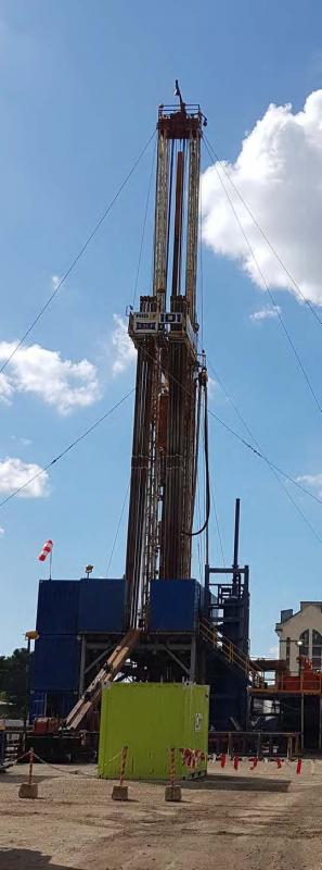
In 2018, the construction work on the main heating plant has been initiated and the first few kilometers of the network built. The remaining network construction activities will be carried out as the new residential areas are built. The wells will be drilled in the second half of 2019.
The geothermal system is set to be commissioned during 2020.
The project is focused on the use of geothermal energy, specifically the resource that is assumed to be present in the Jurassic layer some 1,700 m below the surface. At that depth, the water temperature is expected around 70°C.
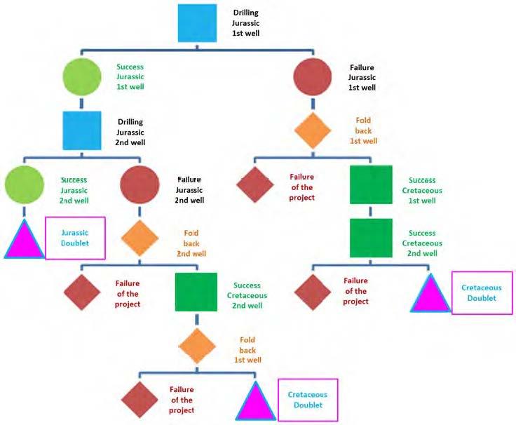
The geothermal resource will be confirmed with tests to assess the water flow rate that could be achieved by the production well. Since there are no similar projects in the Bordeaux area, in-situ exploration is the only way to assess actual flow rates, examine re-injection options and determine the physical and chemical properties of the water. The first drilling operation could have two possible outcomes (Figure 2):
• Total or partial success at the Jurassic layer: a well doublet that extends into the Jurassic layer will be implemented. A well, for re-injecting water, will be drilled into the same Jurassic aquifer. Heat pumps will increase the water’s temperature (70°C) and enable the full potential of the resource to be exploited.
• Failure at the Jurassic layer: a fall back solution allowing for the exploitation of a proven reservoir in the Cretaceous layer, which is located 900 m below the surface and has a water temperature of 45°C, will be implemented. A number of wells in the area already use this resource. In this scenario, the well doublet will be performed at the Cretaceous level.
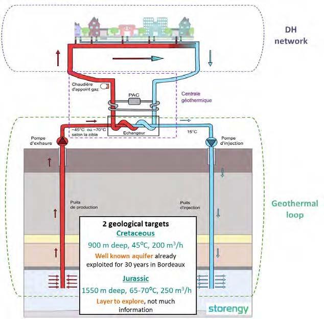
If the Cretaceous aquifer is used, the production of geothermal energy will be lower. A biomass heating plant will be added to the facilities to ensure that enough low-carbon energy is generated to meet renewable energy requirement (Figure 3).
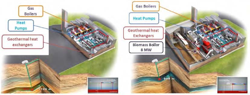
In both scenarios, the future PGE heating network will be supplied with heat from the geothermal well doublet. Gas boilers will act as a backup and cover any consumption peaks (in the event of a cold snap), the aim being to supply 82% carbon-free energy.
PGE is a flagship project for several reasons. It is the first deep geothermal district heating project conducted outside Paris the area in 30 years (the most dense geothermal district heating area). It illustrates the expertise of Storengy and ENGIE Cofely in this market to satisfy the communities’ needs and the customers’ requirements.
At the beginning of the subsurface studies, we gathered the most complete documentation on 1/ already drilled wells from shallow to deeper ones reaching the bottom horizon for the Jurassic layers), 2/ previously published reports and logs performed describing geology, petrophysical properties and well tests information 3/ published interpretations of the regional and local geology and 4/ exploitation data of the wells such as flow rates and withdrawals over time.
All this information was taken into account in the assessment of the resources and the general sketch of the geothermal doublet (well location etc.), the well design, and to investigate the durability of the doublet.
The location of PGE1, the vertical producer well expected to be drilled first in the PGE project, was dictated by the location of the future heat plant. At the beginning of the project, no location was assigned to the injector well (PGE2). The identification of the location of PGE2 was part of the project, depending on the subsurface study and on the available yards on the right bank of the Garonne river; almost the full area being in renovation.
Regionally, around Bordeaux, 9 deep wells were previously drilled. 4 of them reached formations below the Jurassic layers of interest (Figure 4b).
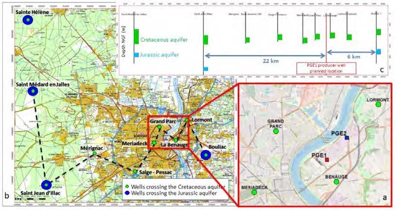
Nearby the PGE1 location:
• Bouliac is the closest well from PGE project that reached the Jurassic formation. It is located, in the southeast, about 6 km away (Figure 4c). It was performed for oil exploration. The well did not show much water, but has never been properly developed and tested for water production. Other Jurassic wells showed water. No information on water productivity was retrieved from logs and records. Few indications on petrophysical parameters are available and tend to show a heterogeneous formation.
• Wells from Merignac to Lormont were drilled in the early 1980ies, for geothermal purpose. They exploited the Cretaceous Formation (Figure 4a and 4b). Petrophysical and water productivity information are quite well known.
The Cretaceous reservoir layers are constituted from top to bottom of approximately 180 m of dolomite, dolomitic limestone and recrystallized micritic limestone, and approximately 30m of alternating fine glauconitic sandstones and medium to coarse sands, which provides about 75% of the total flow rate (data from offset wells ).
The Jurassic reservoir layer is expected to be constituted of 2 sub-layers corresponding to, on one hand, gravelly bioclastic and oolitic limestone (with few sandy to microconglomeratic intercalations) and on the other hand, dolomitized micritic limestone. The porosity of these levels is expected to come mainly from fractures but also from clastic intercalations and dolomitized areas, with an unknown lateral extension.
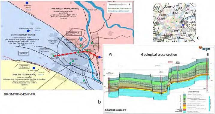
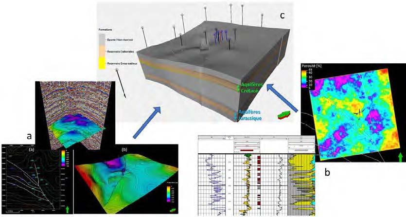
The seismic data in the region were acquired in the 1970ies, avoiding the urbanized area of Bordeaux (Figure 5c). No new seismic campaign was performed since. From this information, and formation well tops, a structural model was proposed by the BRGM (2014 Figure 5a and 2008 Figure 5b) for the Cretaceous formation. No structural model was available for the Jurassic Formation, and we created our own structural 3 D model for the area (Figure 6c), including the Jurassic formation, despite a cruel lack of data for this level.
The 3D geological model (Figure 6c) includes the structural framework and the available petrophysical data.
The structural framework encompasses the fault network, the Upper Cretaceous top map and well data (Figure 6a). The underlying structure is inferred from this information and scare data from Jurassic wells; therefore, it presents consequent uncertainty.
The petrophysical model of cretaceous layer is fed by well logs inputs and well tests interpretations.
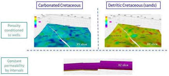
For the Cretaceous, both distributions of net-pay for the calcareous level and the sandy one are obtained from geostatistical simulations, conditioned to well data (Figure 6b). Those realizations allow to derive equivalent porosity and permeability properties.
For the Jurassic reservoir layer, scare data do not allow for an identical workflow. The porosity and permeability distributions of the Jurassic are considered constant (although suspected to be heterogeneous). Values are taken equal to the mean properties of the very well-known Paris Basin Dogger formation which appears to be the best analogue a priori (same depth, similar lithology, and also a proven geothermal resource). The two Jurassic reservoir sublayers are identified in the 3D geological model.
Given the uncertainties and the respective expected heterogeneities of the reservoir formations for both targeted formations, the 3D dynamical simulations where performed using the geological 3D model as an input. Net-pay realizations for both cretaceous intervals are conditioned to well data measurements. Equivalent permeability (and porosity) could be derived then (Figure 7).
For the Cretaceous Formation, as the aquifer is quite intensively exploited for almost 4 decades, the considered initial conditions correspond to the 1976 map of hydraulic heads. Historical withdrawals of the wells where introduced. The calibration of the permeability field was performed using two well tests performed in 1981: the long duration test of La Benauge (and associated interferences measured on Meriadeck and Lormont wells), and the long duration pumping test of Lormont.
The 3D fluid flow and thermal transfer model indicated the favorable locations for the injector well (as several options were initially available) allowing for a 30-year lifetime (without thermal breakthrough) for the geothermal doublet at the Cretaceous.
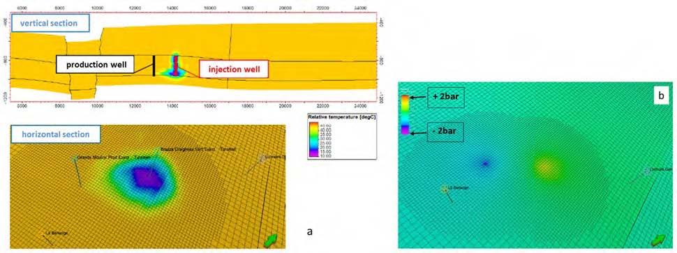
Maximal thermal and pressure impacts were assessed for both the Cretaceous (Figure 8) and Jurassic levels, after a 30-year period with the maximum flow rates (250 and 300 m3/h, respectively to the formations) and a 15°C reinjection temperature.
The impact of temperature at the producer well after 30 years is estimated inferior to 0.5°C, and the pressure impact is estimated to -0.6 bar at the closest well, La Benauge (not used since 2011).
Considering the complexity of the drilling project, and that reinjection is only possible in the exploited aquifer, all outcomes have been assessed (Figure 9), and the wells were designed to ensure all these outcomes.
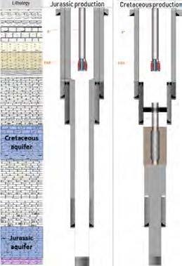
The main principle for the design of the well was to drill in large diameters to allow for all possibilities in vertical wells, with no side tracking, while ensuring well performances to exploit the Jurassic or the Cretaceous.
At the first well (the producer), after reaching the proven layer of the Cretaceous, a short test will be performed to check the expected -proven- resource. The drilling will be then performed to the Jurassic layer and a mixed diameter liner covering entirely the well (except the Jurassic formation) will be installed. This liner will be then cemented but only on the interval separating the Jurassic from Cretaceous.
Both aquifers are then isolated, and the well is then producing only the Jurassic aquifer.
If the short and long duration tests of the Jurassic aquifer show performances suitable for geothermal exploitation, then the liner will be cemented through perforations, and the 2nd well will be performed at the Jurassic level too. If not, then the Jurassic at the first well will be closed/cemented, while the mixed liner will be opened at the Cretaceous the upper part of the liner will be cemented, and the Cretaceous completion (with gravel and screens) will be installed (Figure 10).
The design of the second well is somehow similar to the first one allowing for a possible fallback from Jurassic to Cretaceous. In the end, it is necessary to give the possibility for both wells to fall back in case of a Jurassic success at the first well but deceiving performances at the Jurassic at the second one.
The subsurface studies and the future drilling works (hopefully, successful wells) are part of large project meant to provide several districts with heat. Despite this paper focuses on the subsurface part, the project has also strong developments on surface installations and network. The joint value of Engie Cofely and Storengy partnership on this project resides on the handling of such a project, as well as the efficiency of interactions at the joint point constituted by interdependence of well heads and wells performances and surface installations.
This project illustrates the commitment of the companies on shallow and deep geothermal to serve the communities.
Storengy and Engie Cofely would like to thank the Plaine de Garonne Energies company and the Bordeaux Metropole community, and all their employees involved, now and from the beginning, in the project.
Bugarel, F., Desplan, A., Eveillard, P., Griere, O., Grange, M., Guttierez, T., Malcuit, E., and Piron, E., "Caractérisation des ressources géothermales profondes au droit de la Métropole Bordelaise - Conditions techniques et économiques d’accès à la ressource”, BRGM report, RP-64247-FR, Orléans, France (2014).
Platel, J.-P., Abou Akar, A., and Durst, P., “Etude sur les possibilités de valorization et de reinjection des eaux de rejet des forages géothermiques de Mériadeck et de La Benauge, commune de Bordeaux (Gironde)”, BRGM report, RP-56120-FR, Orléans, France (2008).
BEPH, web access for French geological data, http://www.minergies.fr/fr/cartographie, 2015.